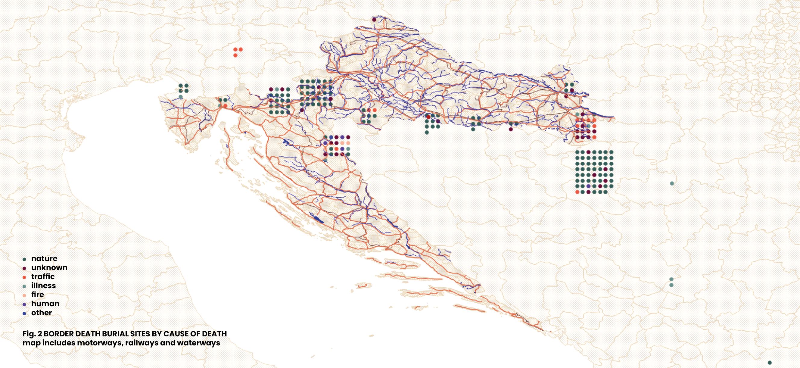
Map of Causes of Death
Border deaths are an integral element of contemporary European border controls. They are not an unexpected side effect, but rather the inevitable element of current migration policies, primarily the visa regime. Border deaths are rarely the result of direct violence, the use of firearms, rubber bullets, batons, tear gas etc. More often violence is outsourced to nature or assigned to an individual's health condition, traffic, or fire. Suffocation, drowning, freezing, or heart attack during the journey, often following extreme physical exertion, are all fatal outcomes of attempts to evade migration controls or being stuck in waiting areas along the EU border. Even when the cause of death is induced by people, those held responsible are rarely representatives of state authorities. More often it is a case of suicide or of death caused by another migrant, a local resident, a smuggler etc.
The map provides a rough outline of specific border death graves geographies formed from the perspective of the causes of death. It shows that the burial sites of those killed by traffic-related accidents are concentrated along the land border between Croatia and Serbia known as Corridor X, one of the most important pan-European transport corridors connecting Central Europe with the southeastern part of the continent and extending further towards the Middle East and Asia. On the map, those who died due to natural forces predominate, which is partly related to the numerous people who died precisely because of this cause, but also because all the unidentified deceased—many of whom lost their lives by drowning—are buried in the country of transit.
This map is part of a series of visualizations of data on migrant graves in Croatia and surrounding countries. For other maps, see: Map of Grave Inscriptions, Map of Grave Locations, Map of Grave Markers and Map of Grave Markers Materials.
***
Border death burial sites marked on this map have been identified based on media reports, personal accounts, data requests todifferent institutions, and field visits to cemeteries. For complementary data about border deaths, see the ERIM Map of Border Deaths and 4D database. Information sources for each burial site shown on the map are provided alongside each location in a dataset available here. The dataset includes several graves outside Croatia that fall beyond the geographic scope of this set of visualizations.The locations of individual graves were recorded using a mobile phone GPS, which may result in slight coordinate variations even for exact positions. These GPS coordinates were then integrated into a GIS (Geographic Information System) tool to produce the maps. For the spatial visualizations, QGIS (open-source mapping software) and professional design software were used to create the maps. Geographic data was obtained from multiple sources including OpenStreetMap, The Humanitarian Data Exchange, and DIVA-GIS.
Documenting border deaths and burial sites was one of the research strands of the international research project ERIM, The European Regime of Irregularized Migration at the Periphery of the EU: From Ethnography to Keywords, coordinated by the Institute of Ethnology and Folklore Research in Zagreb from 2020 to 2024. Following the project's completion, the work has been continued by several former project associates and others.
Gallery