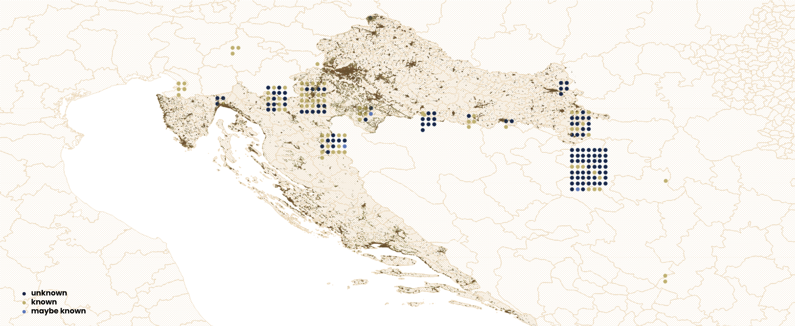
Map of Grave Inscriptions
Many of the found bodies remain unidentified, which can be seen as a continuation of the illegalization enacted during the lifetime of thedeceased. Accordingly, many graves of the deceased at the borders are marked with the inscription “N. N.”. The N. N. could be a son, father, daughter, mother, sister, or a brother who is being sought after by their loved ones. Instead, he or she is nomen nescio. They are missing bodies without names, anonymous, often drowning victims; such graves are found along border rivers like the Sava, Danube, and Kupa/Kolpa.However, not all burial sites without names or marked as N. N. are necessarily graves of people whose identity is unknown. In some cases, the person was identified after burial or their name is known, for example from a camp record, but not officially confirmed. Yet the grave is still marked as that of an unknown person. Sometimes the identity of the deceased is known, as in the case of exhumed graves, but we do not know it. Knowing or not knowing of the name is blurred, entangled in border opacities additionally reinforced by the remoteness of the graves from urban centers and even inhabited areas, as shown on the map below.
This map is part of a series of visualizations of data on migrant graves in Croatia and surrounding countries. For other maps, see: Map of Grave Locations, Map of Causes of Death, Map of Grave Markers and Map of Grave Markers Materials.
***
Border death burial sites marked on this map have been identified based on media reports, personal accounts, data requests to different institutions, and field visits to cemeteries. For complementary data about border deaths, see the ERIM Map of Border Deaths and the 4D database. Information sources for each burial site shown on the map are provided alongside each location in a dataset available here. The dataset includes several graves outside Croatia that fall beyond the geographic scope of this set of visualizations.The locations of individual graves were recorded using a mobile phone GPS, which may result in slight coordinate variations even for exact positions. These GPS coordinates were then integrated into a GIS (Geographic Information System) tool to produce the maps. For the spatial visualizations, QGIS (open-source mapping software) and professional design software were used to create the maps. Geographic data was obtained from multiple sources including OpenStreetMap, The Humanitarian Data Exchange, and DIVA-GIS.
Documenting border deaths and burial sites was one of the research strands of the international research project ERIM, The European Regime of Irregularized Migration at the Periphery of the EU: From Ethnography to Keywords, coordinated by the Institute of Ethnology and Folklore Research in Zagreb from 2020 to 2024. Following the project's completion, the work has been continued by several former project associates and others.
8/12/2025
Gallery