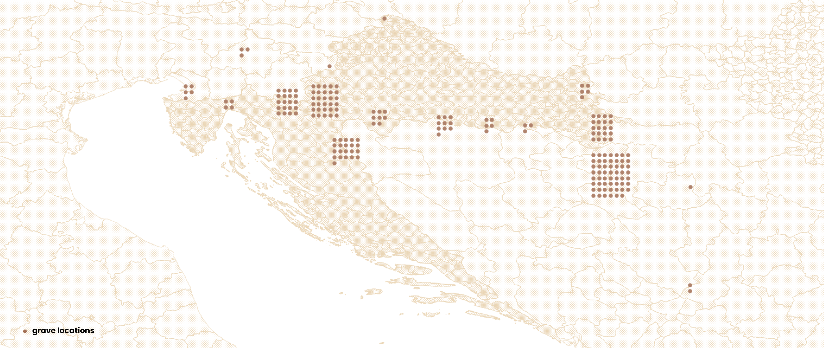
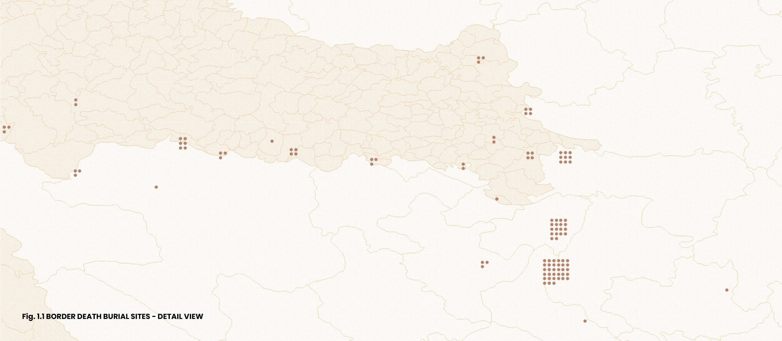
Map of Grave Locations
Graves of people who died while attempting to escape persecution and border controls are scattered throughout transit countries.
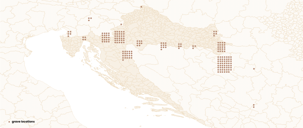
Graves are often in remote areas, closer or further away from the state borders, generally at the margins of the perimeters of local cemeteries, which themselves are often marginalized—abandoned or belonging to shrinking minority communities living in rural areas. The graves thus remain nearly invisible in the physical landscape, while local residents are usually unaware of their existence. However, when marked on a map, their spatial distribution and concentration reveal that border-related deaths are not isolated incidents, but an integral part of the current border regime. Moreover, in some cases—particularly where there is a higher concentration of unidentified graves, as seen in several locations on this map—one can even speak of mass graves. The aggregations in this spatial data visualization frequently connect graves situated on both sides of the border, thereby transgressing a boundary that, ultimately, was the very cause of death for those interred there. What remains imperceptible to the algorithm behind the visualization tools may prove fatal to those compelled to cross that border in secrecy.Areas with a higher density of graves (and cemeteries) appear as point clusters on the map. To address overlapping points, we applied point displacement—a QGIS visualization and rendering technique that slightly offsets overlapping features to make each individual grave site visible, rather than combining them into aggregate counts. While this method reduces spatial precision, it preserves the visibility of individual graves and better conveys the scale of burials in different areas.To better illustrate spatial patterns in high-density areas, we created detailed inset maps focusing on three key areas: border regions between Croatia-Serbia and Croatia-Bosnia and Herzegovina, and the territory spanning from the Croatia-Bosnia and Herzegovina border eastward to the Croatia-Slovenia border westward.
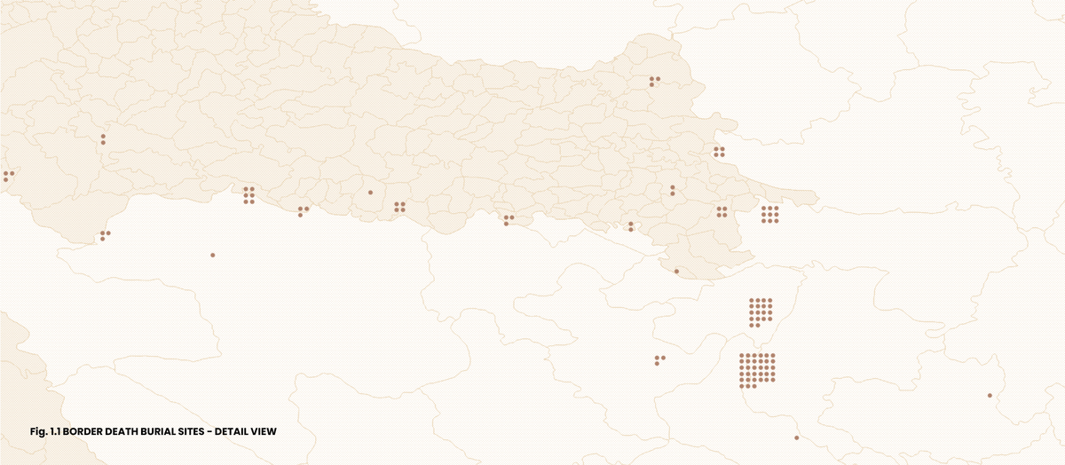
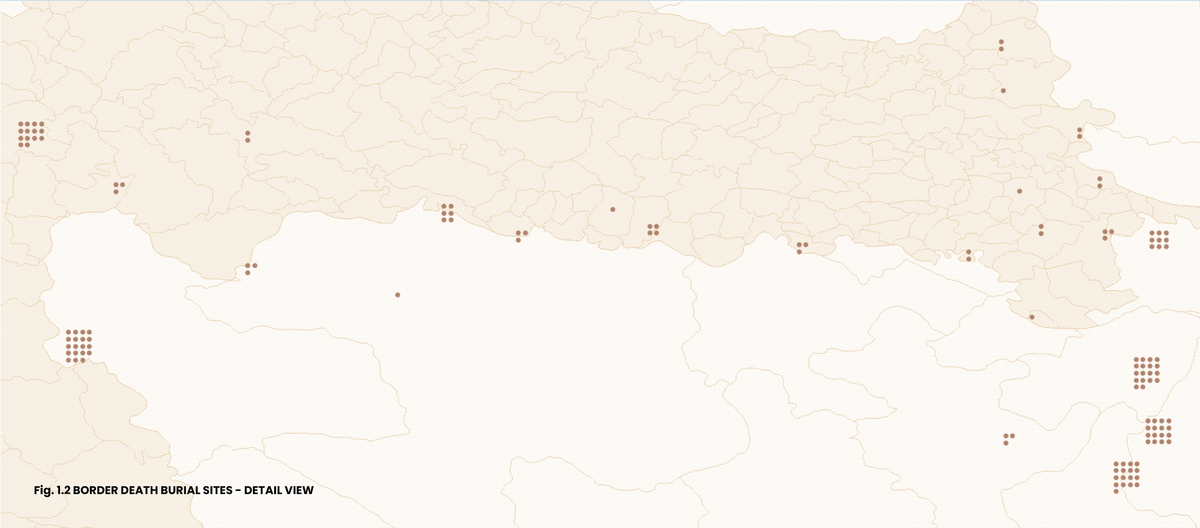
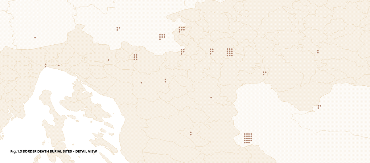
Even at these detailed scales, some closely situated burial sites, due to their proximity, remain visually merged although they are located at different cemeteries—such as distinct cemeteries in Loznica and Karlovac, and some cemetery clusters along the rivers Kupa and Sava. Therefore below is a list of all identified cemeteries:
CROATIA Bilje • Dalj, Dalj Orthodox cemetery • Delnice • Donja Bebrina, Klakar/ Old Cemetery • Donje Prilišće • Gunja, Gunja Muslim Cemetery • Jasenak, Stara crkva Orthodox Cemetery • Karlovac, Jamadol City Cemetery • Karlovac, Sveta Doroteja Cemetery • Karlovac, Jamadol • Kneževi Vinogradi, Kneževi Vinogradi Catholic Cemetery • Kunići Ribnički • Lipa • Lužani • Matulji • Mlaka • Moravice, Sveta Tereza Cemetery • Nijemci • Ogulin, Sveti Jakov City Cemetery • Otok • Popović Brdo • Privlaka • Reštovo • Rijeka, Drenova City Cemetery • Siče • Sisak, Viktorovac City Cemetery • Skakavac • Slavonski Brod, Slavonski Brod City Cemetery • Slunj • Staro Petrovo Selo • Štitar • Štrigova • Topusko • Tovarnik • Uskoci • Vinkovci, Vinkovci City Cemetery • Vrhovine • Vukova Gorica • Vukovar, Dubrava New Cemetery • Žakanje BOSNIA AND HERCEGOVINA Bihać, Humci City Cemetery • Bijeljina, Hase City Cemetery • Bratunac • Golubić, Golubić New Cemetery • Kozarac, Kamičani • Novi Grad, City Muslim Cemetery • Novi Grad, Prekosanje, Prekosanje New Cemetery • Tuzla, Čaklovići Gornji Muslim Cemetery • Velika Obarska • Zvornik SERBIA Lajkovac • Loznica, Loznica City Cemetery • Loznica, Loznica Muslim Cemetery • Sjenica, Baruthana Cemetery • Šid, Šid New Cemetery • Tutin, Kleće Muslim Cemetery SLOVENIA Brežice • Črnomelj, Vojna Vas Cemetery • Ilirska Bistrica • Izola • Kočevje • Ljubljana, Žale Cemetery • Metlika, Rosalnice Cemetery ITALY Trieste, Boršt / Saint'Antonio in Bosco NORTH MACEDONIA Skopje, Butel
These maps are part of a series of visualizations of data on migrant graves in Croatia and surrounding countries. For other maps, see: Map of Grave Inscriptions, Map of Causes of Death, Map of Grave Markers and Map of Grave Markers Materials.
***
Border death burial sites marked on this map have been identified based on media reports, personal accounts, data requests to different institutions, and field visits to cemeteries. For complementary data about border deaths, see the ERIM Map of Border Deaths and the 4D database. Information sources for each burial site shown on the map are provided alongside each location in a dataset available here. The dataset includes several graves outside Croatia that fall beyond the geographic scope of this set of visualizations.The locations of individual graves were recorded using a mobile phone GPS, which may result in slight coordinate variations even for exact positions. These GPS coordinates were then integrated into a GIS (Geographic Information System) tool to produce the maps. For the spatial visualizations, QGIS (open-source mapping software) and professional design software were used to create the maps. Geographic data was obtained from multiple sources including OpenStreetMap, The Humanitarian Data Exchange, and DIVA-GIS.
Documenting border deaths and burial sites was one of the research strands of the international research project ERIM, The European Regime of Irregularized Migration at the Periphery of the EU: From Ethnography to Keywords, coordinated by the Institute of Ethnology and Folklore Research in Zagreb from 2020 to 2024. Following the project's completion, the work has been continued by several former project associates and others.
8/12/2025
Gallery