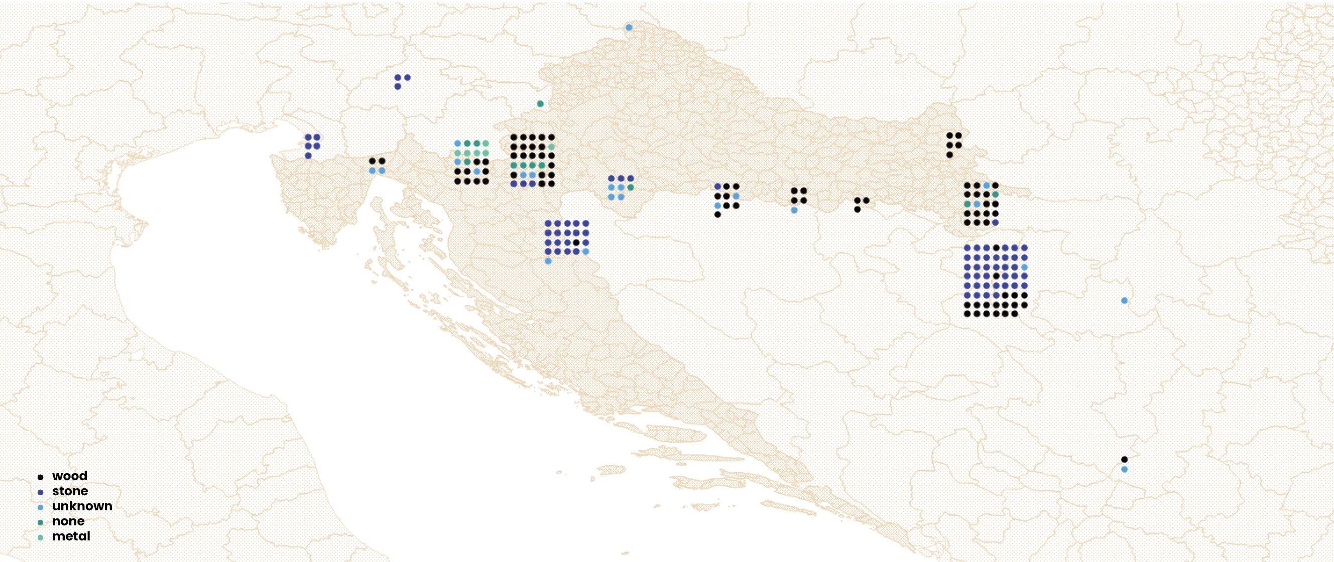
Map of Grave Markers Materials
It is not only the form and symbols, but also the material of grave markers that can indicate the attitude toward the deceased by those who buried them. In most local traditions, the social prestige, wealth, or power of individuals tends to be associated with the material qualities used for their graves—their size, type of material, and aesthetic qualities—indicating the value and durability of social remembrance. In sepulchral traditions that favor durable materials such as stone or various hard metals (bronze, iron, etc.), the predominance of wooden grave markers clearly signals temporariness and ephemerality. Wooden markers decay over time, and the graves they once marked become unmarked and forgotten. The map clearly shows how, in some contexts like Bosnia and Herzegovina, more durable materials dominate, while in others, such as Croatia, they are entirely absent. Additionally, planted flowers or artificial bouquets, placed by local residents can also serve as less ephemeral markers of memory, signaling affection, and care.
This map is part of a series of visualizations of data on migrant graves in Croatia and surrounding countries. For other maps, see: Map of Grave Inscriptions, Map of Grave Locations, Map of Causes of Death and Map of Grave Markers.
***
Border death burial sites marked on this map have been identified based on media reports, personal accounts, data requests to different institutions, and field visits to cemeteries. For complementary data about border deaths, see the ERIM Map of Border Deaths and 4D database. Information sources for each burial site shown on the map are provided alongside each location in a dataset available here. The dataset includes several graves outside Croatia that fall beyond the geographic scope of this set of visualizations.The locations of individual graves were recorded using a mobile phone GPS, which may result in slight coordinate variations even for exact positions. These GPS coordinates were then integrated into a GIS (Geographic Information System) tool to produce the maps. For the spatial visualizations, QGIS (open-source mapping software) and professional design software were used to create the maps. Geographic data was obtained from multiple sources including OpenStreetMap, The Humanitarian Data Exchange, and DIVA-GIS.
Documenting border deaths and burial sites was one of the research strands of the international research project ERIM, The European Regime of Irregularized Migration at the Periphery of the EU: From Ethnography to Keywords, coordinated by the Institute of Ethnology and Folklore Research in Zagreb from 2020 to 2024. Following the project's completion, the work has been continued by several former project associates and others.
8/12/2025
Gallery